Wednesday, December 31, 2008

New Year's Eve


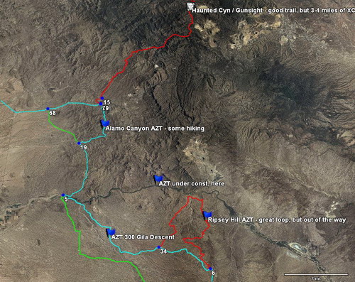
The plan is to do an overnighter on the Arizona Trail since I need to do some pre-riding for the APC. While I am out in this remote section of the AZT, I might possibly hit up some of the new sections of AZ Trail.

Here is a bit of the proposed route

Tuesday, December 30, 2008

Friday, December 26, 2008

Pushing the Limit--Snow Meets Survival


Photo from New York Times Article

In nine years of racing, only 28 men and 2 women have completed the full route to Nome, including Tim Hewitt, a lawyer from Latrobe, Pa., who reached the finish on foot in 2001, 2004 and 2008. About 90 percent of the entrants have dropped out along the trail.

Only seven racers have registered for the 2009 contest, including Hewitt and Basinger. Partly to generate future entries, the organizers have continued to operate a simultaneous 350-mile race ending in the village of McGrath, about a third of the way to the finish.


Watch the video from NY Times on the Idita-Bike.

Read the rest of the article.

Monday, December 22, 2008

Hold

I bit of sore throat today has put my plans for this week on hold. Goat camp was the plan today, although that was canceled this morning with a phone call from Scott. Also, there is some rain in the forecast this week. Today, I am working on buying parts for the new bike build and the Leviathan. Brakes bled, shock fixed, and frame cleaned. I am still anxious to see at least an overnight ride this week, but it seems like it might be extended until next week.

If I ride this one solo, I will probably be heading north on the Arizona Trail (similar to Scott's trip).

Otherwise, I might stay locally and explore some more routes in the Tortolitas. Either way, first I need to rest up.

Dave has a good summary of the recap for 2008. Check it out at his blog.
The 8 Days of Christmas are staring in Tucson, an entire week of mountain biking and Brink has set the challenge for anyone wishing to ride around the Tucson Mountains.

Saturday, December 20, 2008

Tucson Mountain Park Big Friggin' Loop

After a week of searching and exploring sections of the Tucson Mountain Park (see this week's posts), I got to ride the loop around the TMP. I had a little late start and some problems on the trail with the GPS. Rolling out at 6:00 am in the 37 degree weather was kind of interesting. I was thinking about Dave up in Montana and how if he saw me all bundled up (three layers, arm and knee warmers, and a balacava, yes I have to admit it, I was wearing one for some of the road ride until I got to the gasline. Here is a good shot of the gasline road that connects my house to Sweetwater Trailhead.

I did the a loop at Sweetwater before riding out to Camino de Oeste and Starr Pass and the newly built Robles Pass. All three have incredible single track with some great technical sections. It started to warm up as I was ascending the Golden Gate (mile 40ish below). I had to dab several times here.

Sweetwater at Sunset

After a phone conversation with Scott last night about Brown Mountain, I decided that I had to do Brown Mountain. When I got to the bottom of the switchbacks, I almost opted for the shorter route around the mountain. Nope, nope. Let's climb this mountain. Check out the profile below; Brown Mtn is at between mile 48 approximately. It was a combination of hike-a-bike and attempt to ride some of the rock drops.

Brown Mtn with some single track in view on the other mountain.

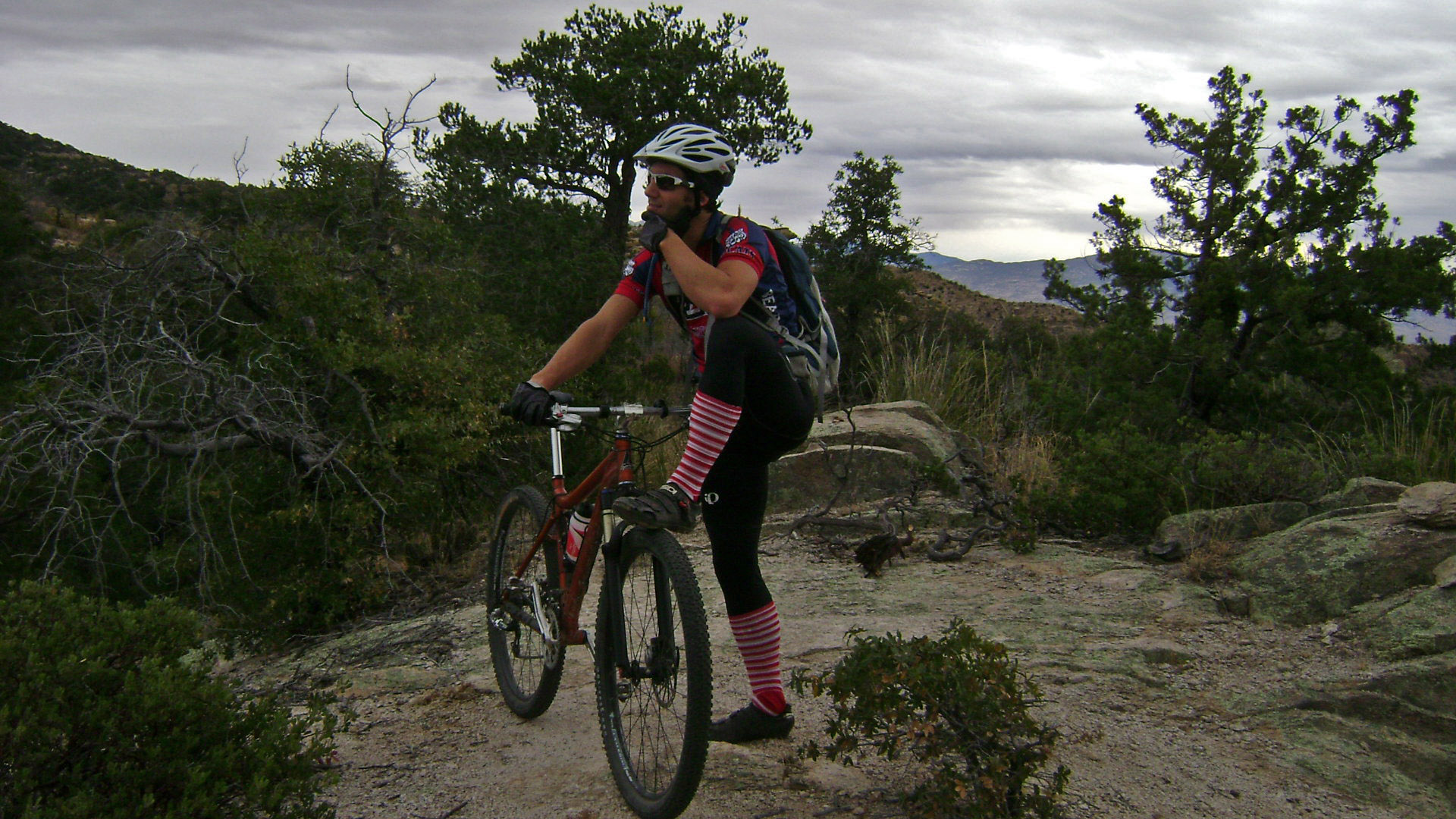
This was also a good time to see how were are feeling. Loving every moment of the ride, check out this smile on the hike-a-bike portion of Brown Mountain...aptly named after its favorite rider :)


After filling up my camelback at the Desert Museum (shamefully, the Osprey 22 bag is mostly full of my warm gear that I used for less than an hour this morning)


it was off to the Saguaro National Park. Some great views along the dirt road for about 10 miles. Here is a good shot looking west toward Tucson while still in the Saguaro NP.


The profile of the 70 miles with 10299 feet of climbing with 8 hours of moving time.


The skinny on the route: about 65% single track, 30% double track and 5% paved roads (since I rode from my house). The trails used in the route: Sweetwater, Starr Pass Trail System, Paso Robles, Brown Mountain.


Friday, December 19, 2008

West Tucson

This week at a glance. 5 out of the 6 days were exploring routes in the west side of Tucson. I know more about this area that any one person would ever care to know. Summary of the routes: 2 new singletrack routes (one small/rideable the other is a bit longer and has some hike-a-bike), a connector to Sweetwater via Camino del Cerro Rd, and a bunch of dead end 4wd routes. This is my favorite aerial shot showing everything I rode this week.

Today, Jim K and I headed out from my house via the gasline to do some loops at Sweetwater with Brian and Renee. Here is a good shot of Brian at the beginning of Sweetwater

Renee and Jim

The crew along with some new friends we met on the route


17 miles, 2200 feet of climbing (turned GPS on/off at Ina/Silverbell area)

Tomorrow is the Tucson Mountain Park Big [Friggin'] Loop

Thursday, December 18, 2008

AES website

The AES website saw a huge surge in traffic after and before Kentucky Camp Epic. Here is the traffic since 12/5 until today.


5-day Weather Forecast
Weather looks great for this next 5 days. Riding to Sweetwater via the gasline road from my house with a friend from work, Mr. Kirk. Saturday should be a long day in the saddle, just waiting to see what Scott has planned. The overnight trip is slated for Monday or Tuesday night.

AZSF Shirt Designs


Courtesey of Dave P!
Vote here.

Wednesday, December 17, 2008

Day 2 of Sunset Singletrack

Another good day on the bike with a lot of climbing, 3222 feet of climbing in 24.11 miles during the 3.5 hour ride. I finally found the connector to Sweetwater for the Tucson Mountain Preserve Big (Friggin') Loop, aka TMP Big Loop. It is a combo of some steep road, fun double track and the occasional single track.

Here is the final section of Sweetwater that I rode before

before heading back on the gasline road.


I ended up taking the gasline road until a little past Wade Rd. Here is a nice shot of the sunset over Safford Peak.


The profile exemplifies some of the steep grades.

This route might not be best for the TMP BFL, but it is a nice training ground for me since it is so close to home.

Cool down was running for about 2 miles.

Tuesday, December 16, 2008

How to become an endurance athlete!

While I was uploading the track for tomorrow's ride, I started playing around with the profile feature on Topofusion. I decided to call this little segment "Becoming an Endurance Athlete Blogger"

The number #1 fastest way to con people into thinking you are fast is to post up crazy graphs... the following is no exception.

crazy, eh? If you did not think I was an endurance rider before, check this out! I find myself doing this sometime, although it is normally just the elevation change.

The #2 fastest way is to start referring to some Coach all the time. Coach has having me do workouts this week. My legs hurt since Coach gave me the plans for this week. Coach. Start adding them to your blogs. It will make you a faster rider and improve your blogging skills immediately. Look at this blog for a good example.

Then comes #3. I used to do this on my old blog. This takes a little time and effort for some bloggers. Make sure to have all your races that you have ever done in the past decade in a side column with links and places of each.

The final #4 segment is to get sponsorships and put them all over the blog. Here is a good example of that.

Sunset Single Track

After checking out some aerial views of the gasline trail and Sweetwater on Sunday, I found some trails that I thought would lead me to Sweetwater and Camino del Cerro. It was too close to tell if the single track was in the Saguaro National Park Boundary, so Eric and I headed out today. First, we had another exciting crossing of the Santa Cruz before riding up Sunset Road to the the single track that I saw from the aerial view. Here is a rough shot of it from Topofusion's new urban view:


The route for the first 1/2 mile was a lot of hike-a-bike mostly from the amount of rocks on the trail. Thereafter, the route seemed to get more rideable and a little bit more technical. A good view of Tucson below.


After about a mile, we ran into the an old abandoned mine, titled Gila Monster Mine on the topo map. Eric checking out the mine.

We eventually got to the park boundary/Thunderbird Trail. The sign said .7 miles to Sweetwater and .9 miles to Camino del Cerro. Denied. National Park boundary...no bikes allowed. We turned around and started to head east to what appeared to be a mansion (it had 3 air conditioners).

We crossed the guy's property with the mansion , who just happened to be driving up about the time we were exiting. Hmmmmm... this has happened before to me. My immediate thought was this is not good.

His face turned from anger to calmness when I mentioned I had been on the State Trust (I saw the sign as we were exiting his house). He offered some good advice about the land around his property and we bid him farewell.

We headed back down to the gasline and again, the park boundary sign was up. Denied. We decided just to head back home via Ina.

After the ride, I checked the topo maps and the park boundary is not even close to this section of the gasline. Beyond that sign, there is a huge amount of DT/ST according to my urban shots. Bummer.

The profile of the ride. More exploring to be done. The route from Sunset ST to Gasline to Ina/1-10 w/ 2206 feet of climbing.


.

Lunch time ride

Single track behind the school


Combined with some tunnel riding in the wash


Edit: This is the end of bad pictures on the blog. The camera arrived today!

Monday, December 15, 2008

Deuces Wild Poker Ride

David Peterson is working on flyers for AES. Check out this first draft that he made for the Deuces Wild Poker Ride. This one and others should start circulating soon. Spread the word.

What do you think?

Sunday, December 14, 2008

Antelope Peak Challenge

Tonight, I started looking at alternative routes for the Antelope Peak Challenge that would decrease the amount of road on the route. From Biosphere II, it looks like we can take some 4wd trails to the south side of Oracle. While looking at aerial views, the idea of jumping onto the control road and the AZ Trail to Tiger Mine Road began to unfold. It would add less road and a lot more mileage (approx 90ish miles).

Here is a topo view of the 4wd trail near Biosphere II (purple line is current route on highway).


Any thoughts about adding more miles? Or how about a 60-mile and 100-mile option?

Large saddlepack


DyneemaX material on this saddlepack and the frame bag to fit the Lenz.

Along DyneemaX material, the frame bag has 500D Cordura along the tubing, water resistant zippers with zipper garages and locking
sliders (weather resistant and quiet), lightweight closed cell foam padding lines tubing (protects your frame, cuts the noise), full sleeve top attachment, and some long trim-to-fit straps along the down tube.

Gasline Road and Sunset


Steve and I headed out for some exploration in my back yard. The result was about 1 mile of single track to link the gasline road to Sweetwater trail head.

Here is a good view of the sunset singletrack that connects the Santa Cruz/Rillito Bike Path to the gasline road.

Eventually the gas line trail connects to Sweetwater and upper Camino de Oeste and then the entrance to Sweetwater trail system.

Today's ride: 24 miles with 2200 feet of climbing, there were about 4 big climbs on the gasline road. This little loop screams night ride! Steve, I am glad you got to come down and ride. Hope to see you soon!

This route would also be used for a great epic ride that Rob and Tim have been discussing. Rob made me realize that we could do an out-n-back from my house to Brown Mountain using the said loop, along with Rob and Tim's suggestions.

The route: My house-urban-Rillito Bike Path-Santa Cruz-Sunset-Sunset Singletrack-Gasline-Sweetwater-Gasline-Greaswood Park-Middle School-Starr Pass-Robles-Golden Gate-Brown up and Over-Back to Tank and go to the Brick House and repeat down gasline.

KCE Results

One of Vern's pictures posted here


See the results here.

Friday, December 12, 2008

The week in riding

Tuesday: Night Ride
Wednesday: Urban night ride with Steve
Thursday: 50-year Trail
Friday: AZT at Sahuarita Rd
Saturday: Kentucky Camp Epic
Sunday: Starr Pass

And a special shout out to my Spanish students who found my blog...read on, and ride on.

Tuesday, December 09, 2008

Urban night ride

I rocked the new candy cane socks. New Sidi Dragon II felt great. The new hanger is on and the old derailleur was not bent too bad. A quick hour spin then off to the gym for an hour run.

The ETA on the bike bags might cause a slight delay on the bikepacking trip (Jeff said they will be sent out on the 19th of December), so I might be doing the PEE on the 20th instead of starting to ride the AZT.

Monday, December 08, 2008

Very nice


Promoting cycling

The federal Bureau of Labor Statistics forecasts the fitness field will grow 27 percent from 2006 to 2016.

When I read this, I immediately thought of an enormous opportunity to increase cycling. Then I had to unfortunately ask myself what I am doing to promote cycling. Sadly, I only had a few answers. Underground races do not really promote cycling, so the AES is out. I volunteer at races from time to time, but I have not in quite sometime.

I pose the question to you now.

What are you doing to increase the amount of cyclists? Build a trail. Be kind on the trail. Volunteer at a race. The list goes on and on.

New training goals should be coupled with new ways to promote cycling. My new plans to help promote cycling: volunteer at a race in the next 4 months, finalize plans for AZSF09 and work on the Arizona Trail as soon as I can.

Sunday, December 07, 2008

KCE Weather


30% showers of rain the day after KCE

Another broken derailleur hanger...

Scott, Paula and I met at Le Buzz today for a late ride up on Lemmon today. It was great to be able to sleep in a bit and the weather was perfect. It was a casual pace up Prison Camp and Bugs, pausing frequently to enjoy the amazing clear day. Everything was going as planned until the 2nd to last climb out of Bugs. Epic failure occurred when I was climbing and a rock jumped up into my spokes and bent my derailleur hanger into my spokes.


I downloaded the new Topofusion version, good stuff. Here is a nice aerial view of Bugs.

Scott and I managed to bend it back and ride the trail down to Prison Camp, where we met Paula. This is where things even got more complicated. It turns out that she unknowingly dropped the car key in the restroom; Scott and I descended to the car only to realize that the key was up at Prison Camp (car is at Molino). Scott rode up to get the key while Paula and I tried to break into the car. No luck. Luckily, Scott managed to find the key and ride back down the trail in about 25 minutes. On the drive back down the mountain, we enjoyed some warm, hot chooclate courtesy of Paula. Mmmmmm...talking about totally redeeming yourself. Lost key + hot chocolate= good times.

Lemmon has claimed 2 of my hangers in the past 4 months (Samaniego Ridge and now Bugs). I just finished putting the new (and last) hanger on the Leviathan.

This was the first time I rode this week, opting for a massive base schedule for running (about 25 miles this week). It is hike-a-bike season in Arizona and training for hike-a-bike requires running, a lot of running.

Thursday, December 04, 2008

Kentucky Camp Epic

From


The race is almost full, only 5 spots left. It is going to be a good weekend. I am working on a better map for the race for those that do not have a GPS. The route will not be marked so cue sheets and/or a GPS are strongly recommended.

Steve (from Oregon) is coming down to ride next week. The plan is to do a quick night ride on Wednesday and possibly a longer loop in Reddington on Thursday. This weekend, plans are in the works for doing some epic rides in Phoenix, possibly a ride at McDowell and/or Hawes on Saturday and Sunday.

Wednesday, December 03, 2008

New commuting route

I found a great new way to get to work that involves 7 miles of double track/single track! My new commuting bike is the Leviathan instead of the road bike. Here is a quick run down of the route.

The route consists of connecting some portions of the CDO Bike Path and the OMNI Bike Path, along with the Horse Track Single Track near El Conquistador shown below (I found this a few months ago). When Scott and Eric and I rode this last week, we rode the wash down, which was awesome. This can only be done on the route home. See picture below for this route.

Otherwise I ride up a connecting wash that drops me off at the stoplight to El Conquistador.

Here is a good shot of the CDO wash connector. You can also ride the road a little bit to connect the wash when the sand is not as hard packed as it is now.


Next bike purchase is definitely going to be a Pugsley. Imagine the endless opportunities on the sand that I would have.

LinkWithin

Related Posts Plugin for WordPress, Blogger...