Saturday, June 30, 2007

Tucson-Green Mountain-Bug Spring-Tucson


We this morning at the Tanque Verde/Bear Canyon Circle K at 4am. It was great spot to leave the car and pick up a cup of joe before the ride. We started a little after 4 up the Lemmon.

We got to Palisades a little before 7am, filled up the bottles, and headed back down to the Uppper Green Mountain TH. It was my first time doing the trail, but it seemed like it was in pretty descent shape. Good steep climbs and some hike-a-bike, oh yes, a good many sections were hike-a-bike. Good times though. Anyway, we chugged along with Naked Guy showing me up on every jump/climb and always in front of me.

At the fork to Bug Springs, we rested for a few mins before heading up one of the steepest trails I have seen in AZ. Again, it was good times and some nice hike-a-bike that allowed me to look over the valley below. The section that was in the wash was sometimes a little hard to follow; but just follow the orange ribbons that are on the trees. More hike-a-bike, but the single track/technical sections that followed were worth every section of the hike-a-bike. Sweet single track at the very end as you exit the trail and get on the hwy. We exited on the hwy at about 10ish, back to the car at 11. We bought some ice cold gatorade and headed home.

Miles according to the odometer: 47.2
Approx Elevation Gain: 6-7k feet

GPS of Green Mountain

Wednesday, June 20, 2007

Great Divide Race


While I was on vacation in northern Arizona, Utah, and LV, the Great Divide Race started. A record-setting 25 racers took off from Port Roosville, MT. Thanks to this Web 2.0 age we live in and the efforts of some amazingly hard-working folks, you can follow along at the website by clicking here

I'm pretty much glued to the coverage and I wish the best of luck to all the racers.

Tuesday, June 19, 2007

Zion National Park


We did 2 new canyons: Fat Man's Misery and Das Boot, then we had to run to LV to see the fam, so we cranked out Keyhole in about one hour. Here are the pictures from the trip:

Hike up to Fat Man

One of the few rappels on Fat Man's
Nice canyon in Fat Man's
Chad in Keyhole
Hike down to Das Boot
Narrows below Fat Man's

Another shot from Fatty Man

Thanks again to the Thomas and Anderson clan for feeding me, letting me shave, and rest at their houses (and Steve, my canyoneering friend, roper hauler, and camerman).

Good picture of the lighting in Fat Man's Misery

Sublime Point, North Rim, Grand Canyon

This trail is the only jeep dirt road open to bikes inside the national park. It is a 19-mile one-way trip that starts about 2 miles from the lodge and goes to one of the best overlooks in the North Rim. I was surprised to see only one car during the entire trip. The trail starts at the Widforss TH. This trail is a classic North Rim trail, offering some sunny meadows and forests full of old pine trees.

The viewpoint has one bathroom (a wall in front of a plastic box with a latched lid) and two picnic tables.

One of the view points before arriving at Sublime Point

It was little hot to sit on the rim in the sun for too long, so I quickly ate, soaked in the view, and headed back to the jeep trail to return to the cooler forest. My camera died when I arrived to the point :(

About 1 mile outside of the car, my cable broke for the back derailer. At first I was a little annoyed, but then I realized that this was my last bike day for the entire trip. Also, when I got back to the car, I noticed that my front fork was leaking some oil and was not working. I decided not to to the KMC because of the issues with my bike. I was sad that I did not do the race, but I had an epic week with friends from Prescott and other friends from the bike shop. I imagine I rode about 350-300 miles during the 6-day mountain bike portion of my trip and ran about 15 miles(Schultz, AZ Trail area, Walnut Canyon, Rainbow Rim Trail, and Sublime Point). I was then off to Zion National Park for the last 3 days.

Rainbow Rim Trail

North Rim, Grand Canyon
Rainbow Rim Trail
June 15, 2007

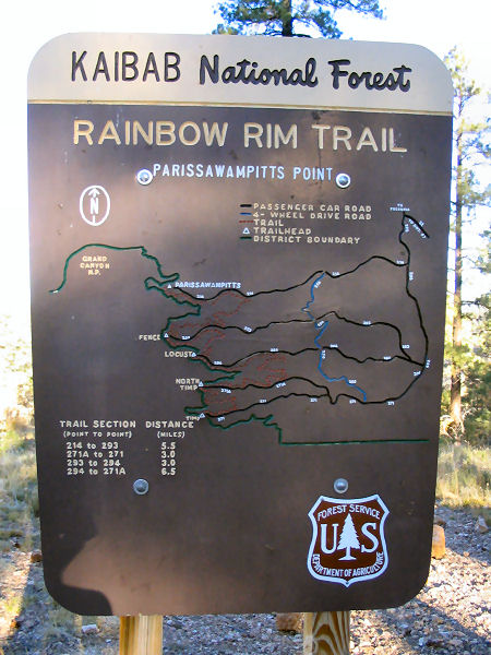
The Rainbow Rim Trail is off Highway 67, a few miles outside of the of the national park. The trail follows thumbs on the rim of the trail for 18 miles from Timp Point to Parissawampitts Points. I drove on Forest Road 22 for about 20 miles to Locust Point, about the middle of the Rainbow Rim Trail. I did this trail in order to see some of the sections of the Kaibab MonsterCross that was last weekend. If you are planning on mountain biking this trail, Locust Point is the best for camping.

My camping spot was about 5 feet from the edge of the rim.


I headed north towards Parissawampitts Point for about 2 hours, carefully navegating the trail as it neared the edge of the canyon. Yes, I set my camera up for these shots and yes I am a nerd for doing it.
A view of the trail

I met some nice, older couples on ATV’s at the end of the trail that cheered for me as I went uphill towards the viewpoint. I chatted with them about my trip and gave them some recommendations about which viewpoints are nice to see. They were the first people I saw on the trail after the 8 miles from my camping spot. I retraced toward Locust Point.

On the ride back, my tubeless tire had some problems (something that was common during my Flagstaff turo). When I got back to the car, I put some more Stan’s gu in the tube in order to seal the tire. I had a quick bagel and continued on to the southern section of the trail. I biked across a family that hired a guide to take them on a 4-day trip. A few minutes after I left them, I biked into the tour guide that was on a single-speed Maverick named Buck.

At Timp Point, I ate the rest of my bagel, rested for a few minutes, hydrated, and headed back to finish the final 10 miles of singletrack. I started at 11am and finsihed the entire trail at bout 4pm.

That night, I did some trail runing for about 5-6 miles before the sunset. I watched the sunset while eating some yummy oatmeal and raisins. Then, I headed back to the camping spot to enjoy some cold beer....Ahhhhhh.


Interested in the Rainbow Rim Trail? Here is some information:

Directions: From Flagstaff drive north on Highway 89. Turn left on Highway 89A and drive to Jacob Lake. Head south on Highway 67 for 26.5 miles and turn right on Forest Road (FR) #22 (sometimes listed as FR #422). Drive 10.5 miles and turn left on FR #206.
Parissawampitts: From FR #206, drive 3.5 miles and turn right onto FR #214 and follow it 8 miles to the Parissawampitts Viewpoint and trailhead.
Fence: From FR #206, drive 5.0 miles and turn right onto FR #271. Go 0.1 miles and turn right onto FR #294, drive another 0.1 miles and turn right onto FR #293 and follow it ~8 miles to the Fence trailhead.
Locust: From FR #206, drive 5.0 miles and turn right onto FR #271. Go 0.1 miles and turn right onto FR #294 and follow it ~8 miles to the Locust trailhead.
North Timp: From FR #206, drive 5.0 miles and turn right onto FR #271. Go 5.0 miles and turn right onto FR #271A and follow it 3 miles to the North Timp trailhead.
Timp: From FR #206, drive 5.0 miles and turn right onto FR #271 and follow it 8 miles to the Timp trailhead.
Sunday, June 10, 2007

Flagstaff Update 6/10/2007

Weatherford Trail

I am camping in the Schutlz area doing all the social trails and trails in the area. The area is below Mt Humprey's on the highway to the Grand Canyon. Yesterday, Dave came up to Flagstaff to show me some social trails that are in the area. We had an amazing ride. He is organizing the KMC race that I am doing this weekend before I head to Zion National Park. Here are some pictures from today (I came down off the mountain and decided to use the wifi at a local coffee shop):
Typical view of the single track in the area

Here is a nice panorama from the top of Mt Elden. It is better if you click on it.

On the top of Weatherford Trail

Friday, June 08, 2007

Zion National Park

Tomorrow I am leaving to go north. I am meeting a friend in Flagstaff to do some technical stuff in and around Elden. Then I am off to the North Rim to do Rainbow Rim Trail while camping in the Locust Campground.

In Zion, the plan is to do Fat Man's Misery, Kolob (if there is a good amount of water being released), and Oak Creek. Here is an old picture I found of me doing Imlay. You can see the Narrows in the background.

Pima Canyon Hike


Here are some pictures from the Pima Canyon hike.
Click here for information about the hike.

Wednesday, June 06, 2007

End to the Gopher Campaign

Those unfamiliar with the gopher story, you need to ask me. Here is a letter from my brother that puts an end to the story:

Dear Chad,

Please make sure you are sitting when you read this email, I am concerned you might take this too hard. I am sorry to be writing this on such a grim occasion, but I regret to inform you that the subject of your rodent tales to family and friends passed into Gopher Eternity this afternoon. I realize the two of you had such a vibrant bonding time in the back yard while you were here for a week in November. The both of you seemed quite gleeful and giddy as I watched you from the back door chasing each other (and as Julie heard you from the bathroom window). Please let me express my deepest sympathies.

Gopher died a good death this afternoon. He had 12 full days of feasting on my freaking broccoli, lettuce, cabbage, sugar peas, and green beans while we were away on vacation, all of which are gone. He had burrowed a tunnel underneath my fence and helped himself to our food....all of it. This afternoon I saw him rummaging again in the garden. I ran into the shop, considered grabbing the hammer you had chased him with in November, but opted for my pitchfork and shovel instead. (If I were not in the city limits, I would have used a gun from my redneck neighbor.) I found the hole he dug and slammed the shovel down in it to prevent him from leaving my garden, then entered the garden with my pitchfork. He was trying to tunnel underneath the fence to get out, but alas despite all his hissing, growling, and spitting at me, his fate had caught up with him. The poor little guy that had half my garden in his tummy was forked to death this afternoon, while trying to escape. I have attached the two images of Gopher for you to see and reminisce. Viewing hours will be tomorrow between 7-10am, before the garbage man arrives to take him to his final resting place.

My deepest condolences,
Josh


Monday, June 04, 2007

Deuces Wild Triathlons

Justin and I drove to Showlow this weekend so I could do two triathlons. The first was the Olympic Road Course (1500 meter swim - 40 km bike - 10 km run) on Saturday and the second as part of the Xterra Off-Road Triathlon (800 meter swim - 24 k mountain bike - 8 km trail run).


The swim section for both triathlons were very challenging as both had a large number of entrants. It was not uncommon to get kicked, hit in the face, or splashed on by other competitors.


Nice shot at the end of the Olympic Triathlon. Yes, I did it on my mt bike.

The best part of the race was that Justin voluntereed as a "stripper" to take off my wet suit for the Olympic Triathlon. I gave him a quick hug and ran off to the T1 (transition 1) to get my bike. The second day, he was directing traffic in the middle of the woods.

The stats from the race this weekend:
Olympic Distance Tri (Road): 69th overall, 3rd in my age bracket (was the only one on a mt bike in the race!)
Xterra Off-Road Tri Race (Mt bike, Mt run): 22nd overall, 2nd in my age bracket
Click here to see the results.

We did stop into La Casita for a quick lunch. I had a the largest combo ever: a #2, a burro, a tostada, and half of Justin's burro. Also filled up with biodiesel at 4th Dimension Fuels in Oracle two times, up and back. Megan, the owner, is very, very nice. They have a sweet gig there in Oracle (was the first biodiesel station in AZ). Made it to Showlow and back on one tank!

LinkWithin

Related Posts Plugin for WordPress, Blogger...