Rainbow Rim Trail
June 15, 2007
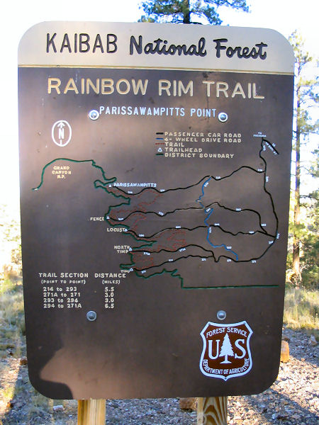
The Rainbow Rim Trail is off Highway 67, a few miles outside of the of the national park. The trail follows thumbs on the rim of the trail for 18 miles from Timp Point to Parissawampitts Points. I drove on Forest Road 22 for about 20 miles to Locust Point, about the middle of the Rainbow Rim Trail. I did this trail in order to see some of the sections of the Kaibab MonsterCross that was last weekend. If you are planning on mountain biking this trail, Locust Point is the best for camping.
My camping spot was about 5 feet from the edge of the rim.

I headed north towards Parissawampitts Point for about 2 hours, carefully navegating the trail as it neared the edge of the canyon. Yes, I set my camera up for these shots and yes I am a nerd for doing it.
 A view of the trail
I met some nice, older couples on ATV’s at the end of the trail that cheered for me as I went uphill towards the viewpoint. I chatted with them about my trip and gave them some recommendations about which viewpoints are nice to see. They were the first people I saw on the trail after the 8 miles from my camping spot. I retraced toward Locust Point.
On the ride back, my tubeless tire had some problems (something that was common during my Flagstaff turo). When I got back to the car, I put some more Stan’s gu in the tube in order to seal the tire. I had a quick bagel and continued on to the southern section of the trail. I biked across a family that hired a guide to take them on a 4-day trip. A few minutes after I left them, I biked into the tour guide that was on a single-speed Maverick named Buck.
At Timp Point, I ate the rest of my bagel, rested for a few minutes, hydrated, and headed back to finish the final 10 miles of singletrack. I started at 11am and finsihed the entire trail at bout 4pm.
That night, I did some trail runing for about 5-6 miles before the sunset. I watched the sunset while eating some yummy oatmeal and raisins. Then, I headed back to the camping spot to enjoy some cold beer....Ahhhhhh.

Interested in the Rainbow Rim Trail? Here is some information:
Directions: From Flagstaff drive north on Highway 89. Turn left on Highway 89A and drive to Jacob Lake. Head south on Highway 67 for 26.5 miles and turn right on Forest Road (FR) #22 (sometimes listed as FR #422). Drive 10.5 miles and turn left on FR #206.
Parissawampitts: From FR #206, drive 3.5 miles and turn right onto FR #214 and follow it 8 miles to the Parissawampitts Viewpoint and trailhead.
Fence: From FR #206, drive 5.0 miles and turn right onto FR #271. Go 0.1 miles and turn right onto FR #294, drive another 0.1 miles and turn right onto FR #293 and follow it ~8 miles to the Fence trailhead.
Locust: From FR #206, drive 5.0 miles and turn right onto FR #271. Go 0.1 miles and turn right onto FR #294 and follow it ~8 miles to the Locust trailhead.
North Timp: From FR #206, drive 5.0 miles and turn right onto FR #271. Go 5.0 miles and turn right onto FR #271A and follow it 3 miles to the North Timp trailhead.
Timp: From FR #206, drive 5.0 miles and turn right onto FR #271 and follow it 8 miles to the Timp trailhead.
1 comment:
Sounds like a great trip. I'm headed out that way in May. Do you need any overnight permits for camping in locust point?
Post a Comment